Showing 38 items matching state forests department
-
 Federation University Historical Collection
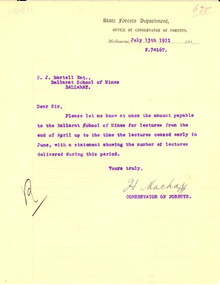
Letter - Correspondence, J. Mackay, State Forests Department letter to Ballarat School of Mines, 1911
... State Forests Department letter to Ballarat School of Mines...Two letters on State Forests Department letterhead from H... Correspondence Letter State Forests Department letter to Ballarat School ...The Ballarat School of Mines provided lecturers during the early era of the Victorian Forestry School, Creswick.Two letters on State Forests Department letterhead from H. Mackay, the Conservator of Forests. The letters are on white lined paper and are typed in blue carbon and were directed to Fred Martell of the Ballarat School of Mines..1) 675 .2) 759ballarat school of mines, victorian forestry school, creswick forestry school, mackay, f.j. martell, martell, forestry -
 Federation University Historical Collection
Letter, Inward Correspondence to the Ballarat School of Mines, 1910, 08/1910
... State Forests Department... State Forests Department Myles B. Webster Photography Albury ...Inward Correspondence to the Ballarat School of Mines, November 1910letterhead, education department, telegram, yarraville chlorination and ore reduction works, a. anderson, h.b. silberberg & co, a.h. walsh, j.m. edgar, charles w. frost, gordon technical college, g. king, jennings deep lead tingha tin mining company, ballarat city board of advice, metallurgical laboratory, s. radcliff, f.w. hall, ararat, gordon technical school, d.c. newham, staffordshire reef, john wilesmith, sandstone western australia, j. worthington, elaine, j. loughman, gold buyers act, h.h. smith, incorporated institute of accountants, james stapp, electric supply companyof victoria, h.j. spencer, tasmanis mines department, david melvin, caulter f. ingpen, hobson's gold mining company, canadian finance and securities, scott hotel steiglitz, g. straight, jubilee mine italians, elsie alcock, dressmaking, w.a. t. davies, legislative assembly, state forests department, myles b. webster, photography, albury, commercial banking company sydney -
 Creswick Campus Historical Collection - University of Melbourne
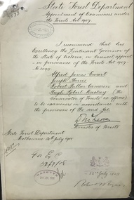
Document, Appointment of examiners under the Forests Act, 1908
... the Forests Act, 1907. State Forests Department. Minister of Forests... is the Appointment of examiners under the Forests Act, 1907. State Forests ...This document is the Appointment of examiners under the Forests Act, 1907. State Forests Department. Minister of Forests, McLeodDocument -
 Forests Commission Retired Personnel Association (FCRPA)
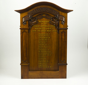
Roll of Honour, State Forest Department
... State Forest Department ... the names of 20 people from the State Forests Department who... the names of 20 people from the State Forests Department who ...Honour boards and rolls were erected in many local schools, halls, churches and offices as a means of acknowledging the commitment made by the community to the military forces. The criteria used for inclusion of names on an honour board were determined by those creating the board and can vary. This board lists the names of 20 people from the State Forests Department who enlisted in WW1. The most significant name is Albert Jacka VC who was perhaps Australia’s finest fighting soldier, and has the honour of being the first Australian to be awarded the Victoria Cross during WW1, the highest decoration for gallantry in the face of the enemy. Most of the other names have been researched.Roll of HonourMembers of the Forest Service of Victoria who enlisted & went to The Great War 1914 - 1919 -
 Ballan Shire Historical Society
Map - Map. Bungal, Department of Lands and Survey, Bungal, County of Grant, 09/09/1926
A map of Bungal in the 1920's showing the allotments, and the size, with the names of the residents. It shows the roads and the Western and Eastern Moorarbool River, and the Whipstick State Forest.Cream coloured map of Bungal in the County of Grant, bounded by the the East Moorarbool River on the East, and the State Forest on the South. It is marked with the scale of chains and the number L.358. Lithographed at the Department of Lands and Survey. Melbourne by W. J. Butson on 9.9.1926. It shows the land allotments with names of owners.Coloured pen marks and circled numbers on various areas. Price 2 shillings marked on bottom right hand edge.bungal, kerrit bareet, egerton, lal lal, borhoneyghurk, bungeeltap, ballark, yaloak, gorong, moorarbool west -
 Ballan Shire Historical Society
Map - Map. Korweinguboora, Department of Lands and Survey, Korweinguboora. Counties of Talbot and Grant
... bullarto korweinguboora moorarbool east dean wombat state forest ...A map of the Korweinguboora area showing roads, forests, railway lines and properties with the owners names.The inclusion of the names of landowners is of significance and value to historians.A map of the Korweinguboora area showing land subdivisions and names of owners and other physical features. There is a scale in chains. No date is certain but it could be 1902. The map has been repaired with sellotape.There are various pencil annotations but the are difficult to read.talbot, moorarbool west, wombat, bullarto, korweinguboora, moorarbool east, dean, wombat state forest, barkstead -
 Federation University Historical Collection
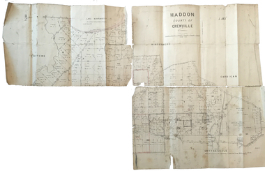
Plan, Haddon County of Grenville, 1887
Parish Plan of Haddon showing the township of Haddon, Cardigan and Haddon State Forest, Lake Burrumbeet and Nentingbook Pre-emptive Right. Names on the allotments include H. Cuthbert, B. Hepburn, T.W. Lloyd, J. Palmer, E.A. Wynne, William Collard Smith, A. Porteous, P. Russell, J. Mitchell, G. Renniehandwritten 'J. H. Cunningham Applic'haddon, cardigan, haddon state forest, lake burrumbeet, nentingbook pre-emptive right, h. cuthbert, b. hepburn, t.w. lloyd, j. palmer, e.a. wynne, william collard smith, a. porteous, p. russell, j. mitchell, g. rennie, j. noone, department of lands and survey -
 Federation University Historical Collection
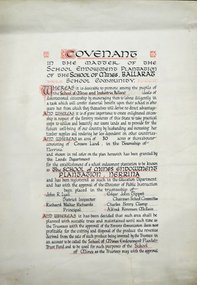
Certificate, Ballarat School of Mines Endowment Plantation, Nerrina Covenant, c1958
Throughout the Nerrina district numerous areas of public land were set aside as school endowment plantations as part of various schools’ educational resources. The plantations were initially established to instil through community involvement a love of forests and an appreciation of their value, and in fact many of them are well suited for regular use as a teaching resource of this nature. It was expected that this use will increase as courses embracing various aspects of environmental science are developed. Many school plantations have been planted to radiata pine, and revenue from the sale of produce used to provide amenities required by the schools. In some cases, however, these plantations have not been very successful in providing revenue, as the sites are unsuitable for economic growth or the plantations are too small or the location too far from processing centres to allow economic harvesting. In some instances, radiata pine plantations have failed due to poor management. In 1982 the Land Conservation Council believed that all the existing plantations should be assessed in order to establish their value as a teaching resource. Those not needed or that are unsuitable for teaching purposes for some reason, such as their location, should be terminated. Those planted to radiata pine that have limited value as a teaching resource although satisfactory for wood production may continue to be used for such production, but should be reviewed when the pines are harvested. (http://www.veac.vic.gov.au/reports/354-Ballarat-Study-Area.pdf, acccessed 30/03/2017) The School Endowment Plantation Scheme was established in 1922 as a joint venture between the Education Department and the FCV. It was administered by the Education Department with technical supervision by the Commission. While some plantations were established on private land donated or leased for the purpose, most were established on Crown Lands or Reserved Forest made available, without cost, by the State. (https://www.victoriasforestryheritage.org.au/community/schools.html, accessed 26 September 2020)Covenant in the matter of the School Endowment Plantation of the School of Mines Ballarat School Community.nerrina pine plantation, ballarat school of mines endowment plantation, nerrina, pine plantation, nerrina, john r. lyall, richard w. richards, dick richards, edgar j. tippett, charles h. clamp, alfred k. mcbain, endowment plantation -
 Federation University Historical Collection
Certificate, Ballarat Junior Technical School Old Boys Association Endowment Plantation, c1928
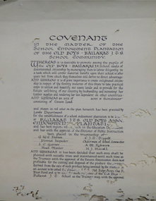
The School Endowment Plantation Scheme was established in 1922 as a joint venture between the Education Department and the FCV. It was administered by the Education Department with technical supervision by the Commission. While some plantations were established on private land donated or leased for the purpose, most were established on Crown Lands or Reserved Forest made available, without cost, by the State. (https://www.victoriasforestryheritage.org.au/community/schools.html, accessed 26 September 2020) Throughout the Nerrina district numerous areas of public land were set aside as school endowment plantations as part of various schools’ educational resources. The plantations were initially established to instil through community involvement a love of forests and an appreciation of their value, and in fact many of them are well suited for regular use as a teaching resource of this nature. It was expected that this use will increase as courses embracing various aspects of environmental science are developed. Many school plantations have been planted to radiata pine, and revenue from the sale of produce used to provide amenities required by the schools. In some cases, however, these plantations have not been very successful in providing revenue, as the sites are unsuitable for economic growth or the plantations are too small or the location too far from processing centres to allow economic harvesting. In some instances, radiata pine plantations have failed due to poor management. In 1982 the Land Conservation Council believed that all the existing plantations should be assessed in order to establish their value as a teaching resource. Those not needed or that are unsuitable for teaching purposes for some reason, such as their location, should be terminated. Those planted to radiata pine that have limited value as a teaching resource although satisfactory for wood production may continue to be used for such production, but should be reviewed when the pines are harvested. (http://www.veac.vic.gov.au/reports/354-Ballarat-Study-Area.pdf, acccessed 30/03/2017)Covenant in the matter of the School Endowment Plantation of the Ballarat Junior Technical School Old Boys Association Endowment Plantation.pine plantation, alfred k. mcbain, g.w.e. pearson, i.c. garner, a.m. robinson, h.j. hassell, ballarat junior technical school old boys association endowment plantation, ballarat junior technical school, alumni -
 Federation University Historical Collection
Certificate, Ballarat Technical School Endowment Plantation, 1928
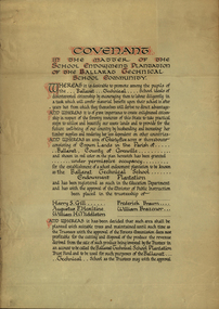
The School Endowment Plantation Scheme was established in 1922 as a joint venture between the Education Department and the FCV. It was administered by the Education Department with technical supervision by the Commission. While some plantations were established on private land donated or leased for the purpose, most were established on Crown Lands or Reserved Forest made available, without cost, by the State. (https://www.victoriasforestryheritage.org.au/community/schools.html, accessed 26 September 2020) Throughout the Nerrina district numerous areas of public land were set aside as school endowment plantations as part of various schools’ educational resources. The plantations were initially established to instil through community involvement a love of forests and an appreciation of their value, and in fact many of them are well suited for regular use as a teaching resource of this nature. It was expected that this use will increase as courses embracing various aspects of environmental science are developed. Many school plantations have been planted to radiata pine, and revenue from the sale of produce used to provide amenities required by the schools. In some cases, however, these plantations have not been very successful in providing revenue, as the sites are unsuitable for economic growth or the plantations are too small or the location too far from processing centres to allow economic harvesting. In some instances, radiata pine plantations have failed due to poor management. In 1982 the Land Conservation Council believed that all the existing plantations should be assessed in order to establish their value as a teaching resource. Those not needed or that are unsuitable for teaching purposes for some reason, such as their location, should be terminated. Those planted to radiata pine that have limited value as a teaching resource although satisfactory for wood production may continue to be used for such production, but should be reviewed when the pines are harvested. (http://www.veac.vic.gov.au/reports/354-Ballarat-Study-Area.pdf, acccessed 30/03/2017) Three A3 page covenant outlining the 35 acres of Crown Land in the Parish Of Ballarat, County of Grenville, to be granted under permissive occupancy for the establishment of a school plantation to be known as the Ballarat Technical School Endowment Plantation, and two letters relating to same, one on green paper. The Ballarat Technical School Endowment Plantation was at Vale Park, Ballarat. Vale Park is near Norman Street, Ballarat. pine plantation, ballarat junior technical school, alumni, ballarat technical school, ballarat technical school endowment plantation, harry s. gill, augustine f. hesiltine, william h. middleton, frederick brawn, william brazenor, a.w. steane, j.b. robinson, vale park, lindsay hillman, a.j. sutherland, oliver r. roberts, w.a. richardson, w.i. watson, j.g. hopwood, g.f. rumpff, e.j. dalker, john b. colbourn, jack r. collins -
Federation University Historical Collection
Booklet, Little Desert National Park and Wail State Forest Proposed Management Plan, 1991, 11/1991
... Little Desert National Park and Wail State Forest Proposed ...Grey soft covered report of 80 pages. Includes a pull out map.little desert national park, wait state forest, management plan, horsham, department of conservation and environment, rod gowans, don spence, wimmera river, threatened plants, fauna, flora, birds, mammals, wergaia, scarred trees, mounds, pest plants, pest animals, tourism and recreation, timber, grazing, conservation -
Federation University Historical Collection
Book, Jacobs Lewis Vines Architects and Conservation Planners, Historic Sites Survey: Ballarat Study Area, 1980
114 page report on historic sites in the Ballarat region. rhistoric sites, ballarat, wendy jacobs, miles lewis, gary vines, berringa, buninyong, creswick, dunnstown, fiery creek, lal lal, langi logan, cathcart, mount cole, mount egerton, nerrina, gong gong, wombat state forest, railways, explorers routes, early roads, land conservation council, ausralian hertiage commission, department of planning, icomos (burra) charter, nigel lewis, richard aitken, freehold land, public land, langi ghiran, new jubille mine, birthday tunnel mine, pitfield plains, smythesdale, buninyong company, mount clear, mt clear, canadian gully, warrenheip distillery, thomas mitchell, waterloo, trawalla, beaufort, raglan, internment camps, forestry, mining, mining, mt egerton, mary hollick collection -
 Marysville & District Historical Society
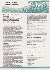
Flyer (item) - Information Flyer, Department of Conservation, Forests & Lands, Lady Talbot Forest Drive, February 1988
A flyer with information on Lady Talbot Forest Drive and the attractions in the area surrounding it.A flyer with information on Lady Talbot Forest Drive and the attractions in the area surrounding it. Lady Talbot Drive a 24 kilometer scenic rainforest car journey which passes a number of walks and waterfalls in the Yarra Ranges National Park. Lady Talbot Drive is named after Lady Sarah Elizabeth, the wife of Sir Reginald Talbot, who was the Governor of Victoria from 25th April, 1904 to 6th July 1908.7761(F1)lady talbot drive, lady talbot forest drive, marysville state forest, sir reginald talbot, lady sarah elizabeth talbot, wishing well, taggerty river, phantom falls, keppel falls, beeches walking track, marysville, mount sugarloaf, logging, victoria, walking tracks -
Federation University Historical Collection
Letter, Inward Correspondence to the Ballarat School of Mines, 1910, 08/1910
Inward Correspondence to the Ballarat School of Mines, August 1910letterhead, education department, gordon, c. brennan, l. eddy, state forests commission, edwin feild, royal victorian institute of architects, the steel company of australia, james martyn, clarke & co, ludwig alberti, scarsdale, thomas m. jude, justinian oxenham, clara davidson, robert davidson, j. roberts, h.b. silberberg & co, l. gilbert, macquarie steam brick yards, james dewar, r.j. flowerday, staffirdshire reef, john wilesmouth, bank of new south wales, victoria silicate brick company ltd, t.s. huggins, george f. roughhead, federal store, legislative assembly, andrew mckissock, city of ballarat, r. e. williams, ballarat school of mines battery assistant, edgar c. hurdsfield, bairnsdale school of mines, w. kingston, gordon technical college, h.l. langdon & co., felton grimwade, f.f. brunn, bendigo school of mines, gold buyers bill, chaffey salmon & dunne, h.j. thwaites, cobar, henry leahy, h. blyth, s. radcliff, archie buchanan, launceston, fairthorne and sons, sloanes and scotchmans united quartz mining company, james eton, albert bradford, 109 lyons st north -
Federation University Historical Collection
Document, Lake Bolac Camp Site
A report on the Lake Bolac Primary School as a school camp by Tony Gough and directed to Graham Beanland and Peter Shiells. The Ballarat School of Mines were looking for a camp site for the school bordering a State Forest. Also includes a comment by Colin McCurry of the Physical Education Department. lake bolac, school camp, colin mccurry, tony gough, graham beanland, peter shiells, pam davies -
 Kiewa Valley Historical Society
Maps - Bogong x2, Tawonga, Omeo, Dargo, Victoria and others, 1. Bogong Alpine Area; 2. Bogong 8324; 3. Tawonga Topographical; 4. Omeo 8433; 5. Dargo 8323; 6. Victoria State
1. Bogong Alpine Area (outdoor Leisure Map. survey & Mapping Victoria, Government of Victoria, Edition 2, reprinted 1991 with an image of Mt. Feathertop on the front. Information for tourist in the Alpine National Park: Bogong Area. Including: recreational activities, history, weather and vegetation and a list of walks together with locality maps and photographs. The front cover has an image of Mt Feathertop against a blue sky with yellow writing 'Bogong Alpine Area', there is a yellow triangular block on the right hand top corner with black writing 'Outdoor Leisure Map. On the bottom edge is a block of yellow with black writing 'Survey & Mapping Victoria' and a light green map of Victoria with 'VICMSP' printed in white. 2. 8324 Bogong Victoria, Edition 1, Commonwealth of Australia 1981. A topographical Map: 1:100,000 scale (1 cm to 1 KM). Map has a red cover with white writing together with a white block and black writing and a map insert. 3. Tawonga Topographical Map - Forests Commission Victoria, / revised 5/9/77, DEG No. 68-G/399. A Tawonga 803 folded map in a beige colour with the back blank. 4. Omeo 8433 Victoria, Edition 1, Department of Natural Resources. The map has a red and white cover with black writing and a simple map of Australia at the bottom. 5. 8323 Dargo, Edition 1, Commonwealth of Australia. A red and white cover with a map insert. 6. Victoria State Map, Hema Maps, 2002. Hema Maps, State Map, colourful cover with a map of Australia and four tourism photographs. Scale 1: 850,000 An inscription handwritten in blue pen "Trappers Gap to Mitta Mitta 1" to 1 mile". There are some pen markings and notations of tracks.maps, bogong, omeo, tawonga, dargo, victoria, bogong alpine area -
 Kiewa Valley Historical Society
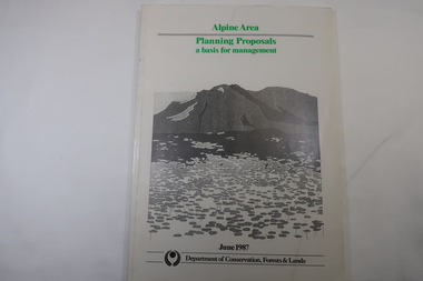
Book - Book - Alpine Area - Department of Conservation, Forests & Lands, Alpine Area / Planning Proposals / a basis for management. 1987
It is the policy of the Government that most of the State's alpine area will be proclaimed as an Alpine National Park, which would complement the Kosciusko National Park in N.S.W.. This is yet to be achieved (1987), however there is a need for sound, efficient and coordinated management based on the area's natural features, values and uses. Planning is proceeding on this basis.Victoria's alpine area is one of the State's most outstanding and spectacular natural areas. It is noted for its diverse plant and animal life, scenery, recreation opportunities and as a water catchment. This country is at the upper end of the Kiewa Valley and the planning for it is of interest to the Kiewa Valley inhabitants.White bound book with green print for title at the top, black & white picture and black print at the bottom for the name of the government authority publishing the book.143 pages with fold out map after page 7. The map is coloured green to indicate the planning area.alpine area, bogong national park, victorian department of conservation forests & lands -
Stawell Historical Society Inc
Map, T.F. McGauran, William Couty of Borong 1891, 1891
Stawell Water Supply Reserve. Grampians State Forest. Dairy Creek, Fyans Creek, Barney's Creek, Bovine Creek, Glasstree Creek, Stoney Creek. Stawell Water Supply Aquaduct Fkuming Tunnel.A2 Parish Map of Willam Inculdin Stawell Water Supply Reserve and Creeks. Marked in redPhoto Lithographed at the Department of Lands and Survey Melbourne. By T.F. McGauran 20.07.91 water supply survey -
 Orbost & District Historical Society
map/poster, Victorian Government Printer, 22.4.1926
The Department of Crown Lands and Survey was originally established in 1857 as part of the Board of Land and Works. In 1964 it ceased to be controlled by the Board. The Department functioned for almost twenty more years before being combined with other Ministries to form the Department of Conservation, Forests and Land. It was responsible for the management of the State's Crown land and pastoral estates. This map was used by Don Mehlert after 1928. The VERMIN AND NOXIOUS WEEDS ACT 1928 was an Act to consolidate the Law relating relating to Vermin and Noxious Weeds. E. J. E. G. Pemberton who published this poster was Superintendent of Field Staff, Dept. of Lands and Survey. This map and posters are significant records of early settlement history in Murrangower, between Cabbage Tree and Orbost,A paper map of Murrangower showing settlement subdivisions. This is glued onto the back of four overlapping cloth poster of "Notices of Vermin Destruction". All print is black."DON MEHLERT" in black pen. Pike's block shaded in blue. School site marked in blue pencil. on poster "MURRANGOWAR" along side.map-murrangower poster-vermin-and-noxious-weeds murrangower-settlement -
 Orbost & District Historical Society
map/brochure, Discovering Marlo & The Snowy River Estuary, December 1988
... In 1983 the Department of Conservation, Forests and Lands... and Survey, the Department of State Forests and the Ministry ...In 1983 the Department of Conservation, Forests and Lands replaced the Department of Crown Lands and Survey, the Department of State Forests and the Ministry for Conservation. This brochure/map was used as tourist information in Orbost.This item is a useful research tool.A folded map/brochure titled "DISCOVERING MARLO & THE SNOWY RIVER ESTUARY". On the front is a photograph of Marlo and the title in yellow print. There is a locality map for access to Corringle beach and the brochure Includes a key to fishing sites and various tourist locations. On the back of the brochure are notes on fishing, wildlife and a boating guide, map brochure snowy-river marlo -
 Warrnambool and District Historical Society Inc.
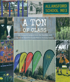
Book, A Ton of Class: 100 favourite recipes from the families and friends of Allansford and District Primary School, 2014
This cookery book was produced in 2014 as a school fundraiser. It was purchased at Allansford Cheese World in January 2015 for $15. Allansford school was established as a National School in 1856 on land reserved for the purpose by John McMahon Allan. It comprised two sandstone classrooms -one for boys and one for girls -with an attached pise teacher's residence. In 1872 when the Victorian Education Department was set up existing schools were listed in alphabetical order and given a number. Allansford State School was No.3. The school was enlarged in the late 1800s and again in the early 1920s. In 1994 following the amalgamation of the Allansford, Allans Forest and Naringal schools a new school was built which adjoined the existing buildings. The old buildings were refurbished as administration and staff facilities. John McMahon Allan settled in the area in 1839 with his brother William Osborne Allan. They were the sons of David Allan, Deputy Commissary General during Macquarie's term of government. The brothers divided the station with William retaining the Allandale portion and John naming his portion Tooram. John McMahon Allan was president of the early district Roads Board. In an attempt to recoup some of the heavy losses due to the disastrous Bateman fire of 1854 John subdivided a portion of Tooram at the Hopkins River crossing known as Allans ford. A school reserve was included in this subdivision. Source: McLeod, Graeme & Barbara. Allansford 1855-2006This book has social and historical interest and significance as it is connected to a local school. It provides a snapshot of food and cooking methods in the early 21st cebturyCookery book with full colour cover featuring 8 photographs and drawings of the Allansford Primary School surrounds and pupil activities on. The images are 'stitched' together with a white zig-zag diamond pattern as if a quilt. The foldout cover has an image of the school's centenary memorial gates and a brief history of the school. Inside the foldout are images of the pupils in each of the school's four team houses. The foldout back cover has full colour images of pupils performing at the school concert. A white strip noting 'our values' is included on the inside back cover foldout. Soft cover, 112 pages.allansford school, a ton of class, allansford primary school, a ton of class recipe book -
 Otway Districts Historical Society
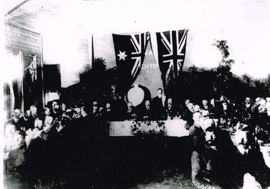
Photograph, Knox Collection, Opening banquet, Colac-Beech Forest railway line, 1902, 27 February 1902
While the first train arrived at Beech Forest on 17 February, 1902, as a special train for a race meeting at Beech Forest Turf Club, two special trains ran for the official opening of the railway by the State Governor, Sir George Sydenham Clarke, KCMG, R.E., F.R.S., that took place on 27 February, 1902. After seeing round the area the guests attended a celebration of the opening at a banquet at Beech Forest. The menu included four impressive courses, coffee and cognac, and included a number of toasts - The King, the Governor, the Minister and the Parliament of the State, Success to the Beech Forest Railway, the Colac Shire Council and the Railway Trust, and the Railway Department, a total of 19 people speaking. The official guests then returned to Colac.B/W. Opening banquet for the Colac-Beech Forest railway line in 1902. The State Governor, Sir George Sydenham Clarke, KCMG, the Premier of Victoria, Hon. A.J. Peacock, MLA, and a number of other important people seated at the top table, with other guests seated to the left and right.beech forest; railways; banquet; colac; -
 Eltham District Historical Society Inc
Document - Binder, Eltham Justice Precinct, 1969-2020
EDHS_04863 - Binder: Eltham Justice Precinct 1. Courthouse 1. Eltham Courthouse interesting facts 2. Plan and elevation drawings 3. Other courthouse plans and fittings 1880s – Brunswick, Maffra, Dunolly , Sunbury, Landsborough and Wodonga 4. Newspaper articles: i. ELTHAM POLICE COURT. (1892, April 1). Evelyn Observer, and South and East Bourke Record (Vic. : 1882 - 1902), p. 2 (MORNING.). Retrieved July 5, 2022, from http://nla.gov.au/nla.news-article60667022 ii. BREAKING A PUBLICAN'S LEG. (1900, July 13). Evelyn Observer, and South and East Bourke Record (Vic. : 1882 - 1902), p. 2 (MORNING.). Retrieved July 5, 2022, from http://nla.gov.au/nla.news-article60688367 iii. ELTHAM COURT. (1901, March 1). Mercury and Weekly Courier (Vic. : 1878 - 1903), p. 3. Retrieved July 5, 2022, from http://nla.gov.au/nla.news-article58578953 iv. ANNIE CHASES A TINKER. (1902, October 3). Evelyn Observer, and South and East Bourke Record (Vic. : 1882 - 1902), p. 2 (MORNING.). Retrieved July 5, 2022, from http://nla.gov.au/nla.news-article64029968 v. ELTHAM POLICE COURT. (1927, May 6). Advertiser (Hurstbridge, Vic. : 1922 - 1939), p. 4 (AFTERNOON). Retrieved July 5, 2022, from http://nla.gov.au/nla.news-article57754748 vi. ELTHAM POLICE COURT. (1927, May 20). Advertiser (Hurstbridge, Vic. : 1922 - 1939), p. 3 (AFTERNOON). Retrieved July 5, 2022, from http://nla.gov.au/nla.news-article57754814 vii. Eltham Police Court (1931, January 9). Advertiser (Hurstbridge, Vic. : 1922 - 1939), p. 4. Retrieved July 5, 2022, from http://nla.gov.au/nla.news-article56734073 viii. Repairs to Eltham Police Station, The Advertiser (1929, May 24). Advertiser (Hurstbridge, Vic. : 1922 - 1939), p. 2 (AFTERNOON.). Retrieved July 5, 2022, from http://nla.gov.au/nla.news-article57759907 ix. ELTHAM COURT. (1929, August 2). Advertiser (Hurstbridge, Vic. : 1922 - 1939), p. 4 (AFTERNOON.). Retrieved July 5, 2022, from http://nla.gov.au/nla.news-article57760345 x. See also Trove list https://trove.nla.gov.au/list/116634 5. Letter: Shire of Eltham Historical Society to Shire of Eltham, 1 July 1969 regarding potential replacement of Eltham Courthouse and the building’s historical significance and acknowledgement 10 July 1969 6. Letter: Shire of Eltham Historical Society to Law Department, 26 May 1972, re preservation of Eltham Courthouse and potential classification and acknowledgement 7 June 1972 7. Newspaper article: Strangers around, so Eltham sought protection by Marguerite Marshall, Diamond Valley News, Tuesday, April 6, 1982, p2 (On reverse side, Top job for our Pauline, p1) 8. Eltham Courthouse Colour Scheme, Public Works Department, 10 September 1983 9. Newspaper article: Eltham Courthouse under threat of closure by Helen Gillman, Diamond Valley News, October 16, 1984 10. Newspaper article: Courthouse to close by Helen Gillman, Diamond Valley News, Tuesday, November 20, 1984, p1 (also on p2 an article about Diamond Valley Shire festivities for the State’s 150th) 11. We will keep your court – Kennett, Diamond Valley News (probable), c.Dec. 1984 12. Letter: Shire of Eltham to Shire of Eltham Historical Society, 15 March 1985, regarding potential for use of building as a museum and reply dated 17 April 1985 regarding Society’s interest in use of the building 13. Letter: Department of Conservation Forests & Lands to Shire of Eltham, August 1987, regarding expressions of interest in the building and letter from Shire (18 August 1987) to Society advising of same 14. Letter: Department of Conservation Forests & Lands to Shire of Eltham, 30 March 1988, advising Courthouse to be used by Eltham Youth Resources Centre and the rear section by other community groups. Noted that the historical society was suggested by Council as a future user of the adjoining police residence when Council first sought management of the building and that should be investigated. Includes Schedule of Repair and Maintenance Work (4 pages), Existing Conditions Survey 30/7/1987 (6 pages) and 1 page plan view diagram 15. Memo: Historic Places Section to Eltham Youth Resource Centre re paint analysis of Courthouse, 17/5/1988, (6 pages) 16. Newspaper article: Courthouse renovation by Jodie Haythorne, Diamond Valley News, November 23, 1992 17. National Trust of Australia Registration (classified 20 Oct 1977), printed March 2000 18. Letter: Heritage Victoria 28 Feb 2002 regarding the replacement of the Courthouse Stand (Witness Box) 19. Article: There’s still order in this stately court house, Eltham Shire (magazine), date unk., p22-23 20. Eltham Court House, Statement of Significance, Heritage Victoria Register, printed Nov 2004 21. Eltham 1860 Former Court House 730 Main Road Eltham, collated by Eltham District Historical Society Incorporated 2005 (4 pages) 22. Book Extract: Eltham, Historical Court Houses of Victoria by Michael Challinger, Palisade Press, 2001 23. Newspaper article: Courthouse rich with history by Harry Gilham, Nillumbik Mail, c.2001 (see also EDHS_03333) 24. Notes on history of site from Crown Reserve File Rs 12128, Municipal Buildings (Local Community Welfare Reserve) at Eltham, Department of Sustainability and Environment, April 2005 (4 pages) 25. Newspaper article: Historic building upgrade, Diamond Valley Leader, August 3, 2005, p17 26. Newspaper article: Courthouse regeneration secures boost, Valley Weekly, August 10, 2005 with picture of Harry Gilham, Steve Herbert and Greg Johnson 27. Newspaper article: Poets are summonsed, Diamond Valley Leader February 22, 2006, p37 features picture of Helen Lucas at the Eltham Courthouse 28. Newspaper article: Sharing a love of legalities, Diamond Valley Leader, March 1, 2006, p7 features a picture of Rob Hulls and Steve Herbert talking to students in the courthouse 29. Newspaper advertisement: Nillumbik Tender No. 2021-33, Building Restoration Works, Old Eltham Courthouse, The Age, November 7, 2020 30. Form: Police Officer’s Return To A Warrant Of Distress 31. Handwritten notes: three pages listing all 48 of the pigeon hole form listings in the cabinet in the courthouse 2. Police Quarters 1. 1971 Surveyors Plan of 728 Main Road and the Adjoining Courthouse 2. Letter: Shire of Eltham to Shire of Eltham Historical Society, 5 June 1981, requesting the society give consideration to the suitability of the existing buildings (former Vermin and Noxious Weeds Office, Department of Crown Lands and Survey) for historical purposes such as a museum 3. Minutes: Shire of Eltham Historical Society Committee Meeting, 10 June 1981 (2 pages) includes reference to possible use of building as a museum (also reference to Bills Horse trough to be retained) 4. Extract from Victoria Police Gazette 1930 with details of building and site 5. Newspaper article: Cubby haven, Diamond Valley News, October 28, 1991 about replica Police Station with picture of replica along with Monika Roitinger and Garry Bartlett outside the Police Station 6. Environment office up for sale? Mountain Views, Monday, June 12, 1995 (Nillumbik Shire Council proposing to sell property. Did not proceed as ownership held by the State of Victoria) 7. Extract from National Trust February 1998 edition, “Police Rescue” which states Heidelberg and Eltham Police Residences are the oldest known Police Residences in the Melbourne Metropolitan district 8. Newspaper article: The first police office by Harry Gilham, Nillumbik Mail, December 13, 2000 (also photocopy with notations on picture identifying buildings and Harry’s typed draft) 9. Fax Memo: Victoria Police List of Officers in Charge, Eltham Police Station, 1857-1991 onward, 21 Jan 2003 10. Former Police Quarters, Statement of Significance, Heritage Victoria Register, printed Nov 2004 11. Eltham 1860 Former Police Quarters 728 Main Road Eltham, collated by Eltham District Historical Society Incorporated 2005 (5 pages) 12. Report: Eltham District Historical Society to Living and Learning Nillumbik, 14 April 2010 regarding the poor state of condition of the former Police Residence 13. Photocopy of three photos of the former Police Residence, former Police Station (relocated to rear of site) and Stables, October 18, 1991 3. Lockup 1. Newspaper article: Heritage permit bid, Diamond Valley News, January 17, 2001 (also article “Eltham library tops”) includes picture of lockup located in Youth Road 2. Newspaper article: Old lockup in new site, Diamond Valley Leader, March 21, 2001, p15. Includes picture of Harry Gilham with lockup at justice Precinct 3. Letter: Victoria Police to Eltham District Historical Society, 20 March 1991 including laser print photo of lockup in 1963 at 23 Pryor Street 4. Fax: Graham Clark, Associated Crane Trucks Pty Ltd, 833 Main Road Hurstbridge; Quote 26.2.99 for $1,080 to move lockup from Youth Road to 728 Main Road 4. Local History Centre 1. Victoria Government Gazette: Photocopy, No. 165, Tuesday, December 7, 1858, establishment of a Court of Petty Sessions at Eltham, 7 December 1858 2. Victoria Government Gazette: Photocopy, September 16, 1859, contract issued for Police buildings at Eltham to Langridge and Co., McCarter, Baillie, Nicol and Co, Chadley, Amos and Co., Cameron, Payne, £1,150.7.0 3. Victoria Government Gazette: Photocopy, October 2, 1860, contract issued for Court of Petty Sessions at Eltham to James Duncan, £600 4. President’s Report, Eltham District Historical Society, Annual General Meeting, Wednesday, March 11, 1998 – covers the establishment of the Local History Centre and new home for the Society 5. Extract for EDHS Newsletter July 1998 – Eltham Local History Centre – Official Opening 6. Unveiling of 728 Street Sign, Speech notes by Cr Dianne Bullen, December 2000, includes invoice from John Sharp Signs Pty Ltd, 24/10/2000 and planning approval drawing dated 24/3/1999 reproduced in Newsletter No. 135 November 2000 7. Letter: Eltham District Historical Society to Living and Learning Centre, undated draft regarding being a member of the committee reviewing the development of the site 8. Notes from Rod Grant re funding of site development under the Community Jobs Program 9. Letter: Eltham District Historical Society to Nillumbik Living and Learning, 28 October 2004 re inclusion of the Society in enhancing the site under the Community Jobs Program 10. Letter: Department of Sustainability and Environment to Eltham District Historical Society, 28 February 2005 re preparing draft Conservation Plan and copy of cover letter in response 2 April 2005 11. Levels and Layout Plan, Nillumbik Shire Council, September 2005, AO copy 12. Letter: Department of Sustainability and Environment to Eltham District Historical Society, 12 September 2005 re Eltham Justice Precinct Conservation Management Plan 13. Letter: Living and Learning Nillumbik, 2 February 2006 to Eltham District Historical Society re forming a Committee to advise on the use, maintenance, management and preservation of the Justice Precinct 14. Minutes: Meeting of a Task group to explore the establishment of a Committee to manage the Eltham Justice Precinct, 20 December 2005 (with hand written notes) 15. President’s notes (EDHS), General Meeting item, 11 May 2006 pertaining to use and condition of the Eltham Justice Precinct 16. Paint estimates, Old Eltham Court House, undated 17. Notes from meeting 26 September (2006), Eltham Justice Precinct Committee 18. Notes from meeting 27 November (2006), Eltham Justice Precinct Committee 19. Terms of Reference for the Eltham Justice Precinct Committee, Draft for Living and Learning Committee Meeting 24 Jan 2007 (4 pages) 20. Newspaper article: Panel set up, Diamond Valley Leader, 7 March 2007 21. Minutes: Meeting of Eltham Justice Precinct Subcommittee, 10 May 2007 22. Minutes: Meeting of Eltham Justice Precinct Subcommittee, 5 July 2007 23. Minutes: Meeting of Eltham Justice Precinct Subcommittee, 11 October 2007 24. Minutes: Meeting of Eltham Justice Precinct Subcommittee, 7 February 2008 25. Minutes: Meeting of Eltham Justice Precinct Subcommittee, 10 April 2008 26. Minutes: Meeting of Eltham Justice Precinct Subcommittee, 14 August 2008 27. Letter: EDHS (Sue Law) to Living and Learning, 6 September 2008 re proposed signage 28. Agenda: Meeting of Eltham Justice Precinct Subcommittee, 16 October 2008 29. Suggested guidelines for use of the Court House for exhibitions 30. Handwritten note re Ken Eckersal and Uniting Church of possible donation of church organ for sale, proceeds to be used for activities at the Justice precinct 31. One page typed notes on each of the buildings in the Eltham Justice Precinct 5. Miscellaneous 1. Photocopy from Pioneers & Painters (2 pages) covering the establishment of Police and Court of Petty Sessions at Eltham 2. Photocopy of photo looking northeast across Little Eltham buildings c.1910 with notes 3. Photocopy of J.H Clarke photo looking up Maria Street from near Dalton Street with notes identifying precinct buildings 4. Photocopy of photo of Court House and Police Quarters with cow outside from Heather Jenkins scrapbook with notes identifying buildings 5. Sketch and notes with dimensions for blue stone lockup including other miscellaneous handwritten notes 6. Unidentified heritage review details of Justice Precinct (c.2004) 7. Hand written notes of telephone conversation held with Dennis McKay (6 May 1997) re Council use of site 8. Flyer: Victoria Police Historical Unit 9. Photocopy of thumbnail images of various Justice Precincts (not identified) 10. Email correspondence, 4 and 10 January 2008; J. Connor to Council and Councillors pertaining to proposed new toilet facilities at rear of Courthouse annexe. Two ring lever arch binder, white with various photocopies, printouts, newspaper clippingsHG Folders 15/52/59 integratedharry gilham collection, eltham courthouse, eltham justice precinct, eltham police residence, lockup, eltham community festival, eltham festival, eltham, heritage assessment, police residence -
Clunes Museum
Document - TIMBER LICENCE
.2 TWO PAGES OUT OF LICENCE BOOK 12 8TH APRIL 1903 TO HARVEST WOOD IN STATE FOREST IN CAMPBELLTOWN LICENCE EXPIRES 7 JULY 1903 .2 BOOK 375 NO 1 TO NO 24 TIMBER LICENCE ORDINARY WOOD, DATED 23 OCTOBER 1901 TO 29/07/1903.2 ON FRONT A WHITE ROUND STICKER WITH "16". ON THE BACK HANDWRITTEN 8/9/04timber licence, department of land and survey -
Whitehorse Historical Society Inc.
Map, Shire of Blackburn and Mitcham, 1938
Plan of Shire of Blackburn and Mitcham showing sections and lot numbers. Scale 8 chains to 1 inch.Plan of Shire of Blackburn and Mitcham showing sections and lot numbers. Scale 8 chains to 1 inch.Plan of Shire of Blackburn and Mitcham showing sections and lot numbers. Scale 8 chains to 1 inch.shire of blackburn and mitcham, blackburn, blackburn north, blackburn south, burwood east, forest hill, mitcham, nunawading, vermont, vermont south -
Whitehorse Historical Society Inc.
Map, Shire of Blackburn and Mitcham, 10/10/1939 update
Map of Shire of Blackburn and Mitcham showing Departmental ball hydrants and departmental pillar ball hydrants.Map of Shire of Blackburn and Mitcham showing Departmental ball hydrants and departmental pillar ball hydrants. Scale 8 chains to 1 inch.Map of Shire of Blackburn and Mitcham showing Departmental ball hydrants and departmental pillar ball hydrants.shire of blackburn and mitcham, fire hydrants, blackburn, blackburn north, blackburn south, burwood east, forest hill, mitcham, nunawading, vermont, vermont south -
 Whitehorse Historical Society Inc.
Document - Centenary History of State Education in Victoria, Victorian Education Department, Centenary History, 1973
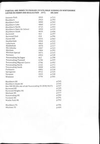
Selected pages of schools in the Nunawading area from "Vision and Realisation". A Centenary History of State Education in Victoria. N.B. State schools are now called Primary SchoolsA list and description of schools in Whitehorse from "Vision and Realisation"A4 photocopy of 58 selected pages from "Vision and Realisation": a "Centenary History of State Education in Victoria" by the Victorian Education Department. Volume 3 dealing with schools in the Nunawading areavictorian education department, burwood east state school no.454, nunawading (sagoe common school) (box hill) no.463, nunawading (boroondara) catholic school no.464, nunawading state school (canterbury road) no.469, vermont state school. no 1022, burwood east state school no 461, nunawading north state school no 2242, mitcham state school no.2904, blackburn state school no.2923, blackburn open air school no.3850, blackburn south state school no. 4035, nunawading state school no.4190, forest hill state school no.4251, nunawading migrant centre no.4706, blackburn north state school no.4715, tally ho training farm no.3588, winlaton girls youth training centre no.4794, blackburn east state school no.4800, nunawading south state school no.4808, antonio park state school no.4844, blackburn lake state school no.4860, laburnun state school no.4863, mitcham special school no.4871, blackburn high school, blackburn south high school, mitcham high school, nunawading high school, vermont high school, mitcham technical school, primary schools, secondary schools, blackburn technical school -
Clunes Museum
BOOK - LICENCE, DEPARTMENT OF LAND AND SURVEY, TIMBER LICENCE, ORDINARY WOOD 5/
RECEIPTS ISSUED BY DEPARTMENT OF LANDS AND SURVEY TO CUT AND TAKE AWAY WOOD. ISSUED EACH QUARTER. LOCALITY - ALL CROWN LANDS, NOT BEING IN STATE FORESTS OR RESERVES FOR ANY SPECIAL PURPOSE. GUM, STRINGYBARK, BOX, MESSMATE AND OTHER KINDS OF EUCALYPTUS TIMBER EXCEPTING RED GUM AND IRON BARK.BLUE CARDBOARD COVERED BOOK CONTAINING TIMBER LICENCES FOR ORDINARY WOOD, COSTING 5/- .1 COVERS 1886 - 1887 RECEIPT NUMBERS 181901 - 181925 .2 COVERS 1885 - 1886 RECEIPT NUMBERS 185276 - 185300 DETAILS OF NAMES OF PERSONS LICENCES ISSUED TO ATTACHED TO BACK OF BOOKSlocal history, receipt books, early citizens, wood licences -
Federation University Historical Collection
Booklet - Booklet - Media Clippings, University of Ballarat: Community Service Activities, 1994
Booklet of article that appeared in the newspaper outlining events, programmes, etc. that are of community involvement. Computer and IT programmes; Uni helps kids learn about safe, active, healthy life; Uni eager to foster partnership with local community; Professor David James (Vice Chancellor) to be chair of regional consultation group reforming State's planning system; Ballarat's Martin Hughes of BU Geology Department and Queensland's Neil Phillips to present paper at Geological Society of America in Seattle; Uni to build aquatic centre to attract top swimmers; Open Days planned by Ballarat Universities; Sue Hadden, Ballarat Uni, received $75,000 grant to carry out research on Victoria's disappearing native grasses; Ballarat Uni to host major student sculpture show; Moves to develop high-tech park plan; New Research Plans assisted by Professor Tom O'Donnell; Indian experts look for answers to get more from their depleted desert forests; Uni conducts nursing survey re courses to be offered; Rabbit numbers rise - survey from farmers; Ted Lovett, VFL footballer (Fitzroy) talk on racism in sport at Ballarat Uni.; Australian beer awards at Ballarat Uni.; Study on Unhealthy Fitness - Heart Foundation suggests regular exercise at level suited to individual needs; Survey tracks path of yellow spotting; Tertiary push for hospital - Ararat; University considered for athletics facility; Top-level study on fitness for the elderly to be monitored by Human Movement and Sports Science students, University of Ballarat; Institute of Chartered Accountants will hold its annual accounting information day at the University of Ballarat's Foundation Hall. Students from other universities to attend; Prince Edward's visit - challenge of "Great Rubber Tube Raft Regatta" at Lake Wendouree; Uni, company in joint training initiative - installation on Novell's networking software in the degree course; Uni begins study into tree threat; Eureka leadership conference in Ballarat; Leadership conference an outstanding success.Buff coloured cover, black print. Pages glued and bound - black tape. Newspaper articles - photographs and print - on separate sheets in reverse order of appearance in paper; December to February.Symbol of University of Ballarat - cover.computer and it, newspaper items, health, local community involvement, david james, vice chancellor, state's planning system, martin hughes, geology department, neil phillips, queensland university, geological society of america, seattle, aquatic centre, sue hadden, research grant, $75000, native grasses, sculpture exhibitiontom o'donnell, indian experts, nursing survey, rabbit survey, ted lovett, footballer, racism in sport, australian beer awards, unhealthy fitness, heart foundation, athletics facility, fitness for the elderly, human movement and sports science, intitute of chartered accountants, networking system in degree course, eureka leadership conference -
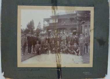 Creswick Campus Historical Collection - University of Melbourne
Photograph - Photograph of Department Forestry Refresher Course, 1913, R. Morton, Forestry Refresher Course, 1913
Department Forestry Refresher Course, 1913. The photograph shows the Conservator of Forests, H MacKay and the Chief Superintendent of State Plantations, John Johnstone, with the Forest Officers of the department outside the Victorian School of Forestry (Tremearne House) in Creswick.sepia photograph mounted on cardboard with separate cardboard backing.On the front: With compliments, Conservator of Forests. R. Morton Photo. Creswick. On the Back: Photo presented to Forester J.S.Ritchie, Glen Park. Passed down to Asst Supt Pltns. W.Ritchie and finally Divl Forester N.E. Division, R.J. Ritchie. On separate card backing: Forest Officers (with list of names) including J.Johnstone Chief Supt of Plantations, H McKay Conservator of Forests